In 2018 we will focus on the preparation of the OBS stations. Altogether, we will have 12 broadband and 9 short-period OBS. They will be deployed in the 2018-2019 survey Figure (4), along the Bransfield Strait, from Deception Island to King George. In the original proposal we proposed that Edifice A and Orca seamounts were surrounded by OBS stations, both of broadband and short-period type. We also designed a more extended network along the Central basin and near the rift zone with the aim of studing the seismicity of the whole basin and the South Shetland trench.

Figura (4): Provisional distribution of rough positions in which it is pretended to deploy the permanent land stations (blue triangles better see Season 2017-2018). The OBS stations will be deployed, roughly, at positions marked with black stars (short period OBS stations) and blue stars (broadband OBS stations).
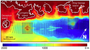
Just after the OBS deployment, we will carry out a seismic exploration of the Bransfield Strait based on reflection seismological profiles. The objective is to obtain the shallow velocity structure along the rift and selected volcanic structures Figure (5). At the same time, we will use the available geophysical instruments on board R/V Hespérides to obtain measurements of gravity, magnetic field, bathymetry, sediment profiles, etc.
We focus on a region of 140 kilometers by 40 kilometers along the strait, that contains the Central Basin and the main volcanoes. The profiles will be obtained perpendicularly to the direction of the rift to improve the detection of lateral heterogeneities.
Also in the 2018-2019 survey, we will inspect the land stations installed in 2017-2018 season. The objective will be the maintenance of the instruments and the gathering of the recorded data.
The instrumentation that is limited to 4 months by the limitations of the acquisition systems will be recovered at the end of the 2018-2019 season. BRAVOSEIS will end the field works at the end of the 2019-2020 survey.

Figure (5): Scheme of the reflection seismological profiles. The black solid lines show the SSE – NNW profiles with a spacing of 1 kilometer in the denser regions and 3 kilometers in less dense regions. The black boxes point out the volcanoes in which studies are going to be centered.
